MAREEBA
The town is 417 metres (1,368 ft) above sea level on the confluence of the Barron River, Granite Creek and Emerald Creek.
 The town's name is derived from an Aboriginal word. In the local Aboriginal language, Mareeba means meeting of the waters - referring to the point at which the Barron River is joined by Granite Creek. Prior to European settlement, the area around Mareeba was inhabited by the Muluridji people. They maintained a hunter/gatherer existence in the area between Mount Carbine, Mareeba, Rumula and Woodville, mainly concentrated between Bibhoora and Mount Molloy.
The Muluridji people roamed the area that is now known as Mareeba town. The area is home to many other Aboriginal people, including the Yirrganydji people, the Kuku Yalanji people, the Djungan people, the Bar-Barrum people, and the Walkamin people. The Mareeba area currently has a large indigenous population, as well as a host of other nationalities.
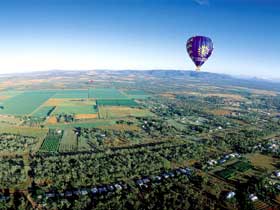
Mareeba is a busy commercial centre that services Cape York and the Gulf of Carpentaria. It is known for its horticulture industries. Numerous crops are grown throughout the Mareeba area, including avocados, mangoes, lychees, longans, sugar cane, cashews, macadamias, pineapples, tea tree, coffee, and a variety of vegetables and tropical fruits. Poultry and cattle are also common.
Climate
Mareeba on average has 300 Sunny Days per year with two distinct seasons:
Dry/Winter (April to September):
-
Little rainfall with mild to warm conditions
-
Average temperatures are maximum 25°C, minimum 5°C -14°C
-
Humidity levels are low, averaging between 64% - 68% in July
Wet/Summer (October to March):
-
Heaviest rain falling from January onwards, average 903mm falling January to April
-
Average temperatures are maximum 38°C, minimum 21°C
-
Humidity levels average between 68% - 75%
Current weather forecast for Mareeba. Mareeba Climate Statistics
Mareeba is considered the 'Gateway to the Gulf' and the headwaters of the mighty Mitchell River which winds its way westwards towards the gulf. An area of rugged topography, its geology includes:
-
areas of basalt plains formed by lava flows in the east and southeast of the shire.
-
exposed granite mountaintops.
-
rugged gorges and escarpments.
-
limestone caves.
Vegetation ranges from World Heritage rainforest to the east, to dry savannah woodlands in the west. To the north lies the Hann Tableland National Park, home to towering kauri and hoop pines that have remained untouched for thousands of years. Rich gallery forests flank the park's major watercourses.
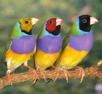
One of Australia's premium conservation and wildlife reserves, is situated 22km from the town. The Reserve, known locally as the Mareeba Wetlands, protects over 5000 acres of savannas and wetlands, providing a sanctuary for much of tropical Australia's savanna and wetland flora and fauna, and cultural heritage.
The Mareeba Tropical Savanna and Wetland Reserve is a unique community conservation project combining valuable conservation work with environmental education and nature based tourism. With the assistance of volunteers it is run by a not-for-profit environmental organisation, the Wildlife Conservancy of Tropical Queensland, and all income realised from sustainable tourism is reinvested into managing the wetlands as well as valuable wetlands and savanna research work, education and conservation programmes such as the critical Gouldian Finch re-introduction programme.
Education
Mareeba has two primary schools, two secondary schools and a TAFE campus.
- St Thomas of Villanova Catholic Primary School
- Mareeba State Primary School
- Mareeba State High School
- St. Stephen's Catholic College
- Tropical North Institute of TAFE
Health
Mareeba Hospital is in the Tablelands Health District. It provides 52 beds, with surgical, maternity, paediatric, outpatient, emergency and x-ray facilities.
Sport, Events and Media
Mareeba's local sporting teams are:
- Rugby league — Mareeba Gladiators: The Gladiators participate in the Cairns District Rugby League competition. They last won the Premiership in 2007.
- Football (soccer) — The Mareeba United Football Club, known as the Mareeba Bulls: the Bulls have dominated the local football scene for the past decade. The sustained success of the Bulls has brought the title for Mareeba as 'Football Capital of North Queensland'. In 2009, the Mareeba Bulls entered the Queensland State League, as the FNQ Bulls, incorporating the entire FNQ Football area, being based at the Bulls home ground at Borzi Park, Mareeba.
Both the Mareeba Karting Club and the Far North Queensland Motorcycle club hold monthly race meetings at the Makotrac International Racetrack which is located five kilometres from Mareeba.
Rodeo:The Mareeba Rodeo takes place over a weekend each July. The first rodeo was held 1949 at Davies Park (which is now the home ground of the Gladiators Rugby League team). On the Friday night, there is a parade through the town, and the Rodeo Princess is crowned (the first Princess was crowned in 1959). Over the rest of the weekend the rodeo proper is held at Kerribee Park. A ute muster is often staged over the same weekend as the rodeo.
Radio: Mareeba is serviced by the following radio stations:
Music Festival
The Walkamin Country Music Association Festival is held at Kerribee Park, annually in October.